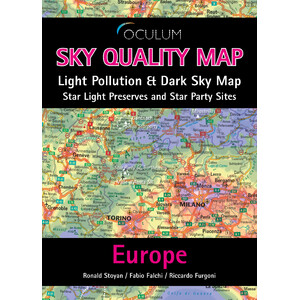
Light pollution map for planning, environmental protection, astronomy
The Sky Quality Map Deutschland is a comprehensive source of information for anyone looking for dark skies or wanting to know the extent of light pollution in their region.
The data is based on satellite data processed by renowned Italian researchers Fabio Falchi and Riccardo Furgoni.
were calculated taking into account numerous factors so that they provide a scientifically reliable statement about the artificial brightening of the night sky. This value, expressed as the ratio of the brightness of the sky compared to a natural starry sky, is colour-coded on the map. It can also be expressed by the increase in the surface brightness of the sky (in magnitude/square arc second) or by the loss of the number of stars visible to the naked eye.
The map is based on a high-quality topographical map. This map also shows smaller towns, bodies of water, railway lines, motorways
and roads are also marked on this map. The map can therefore be used not only as a basis for planning, but also as an orientation aid.
Additional content includes regions such as Dark Sky Parks and Dark Sky Reserves, where the protection of the night sky is a priority, as well as locations where telescope meetings are held.
The map is in A1 format, printed on both sides, and comes folded to A5 with a water-resistant cover.